

Overview
| Name | Wulong Karst 武隆喀斯特 |
| Web address | https://parkofchina.com/en/wulongkarst.html |
| Designation | UNESCO World Heritage (natural, 2007): part of “South China Karst” AAAAA tourist attraction (2011, “Wulong Karst Tourist Area (Three Natural Bridges, Fairy Mountain, Furong Cave)”) National geopark (“Wulong Karst National Geopark”) |
| Location | Wulong District, Chongqing |
| Highlights | Natural bridges, tiankengs, caves, gorges, upland meadows |
| Top sights | Three Natural Bridges, Qingkou Tiankeng, Furong Cave, Fairy Mountain |
| Coordinates | 29.44, 107.80 Google Maps |
| Nearby cities | Pengshui Miao and Tujia Autonomous County ↘︎39km, Fengdu County ↑︎48km, Chongqing ←︎119km |
| Nearby airports | Chongqing Xiannüshan Airport ←︎11km, Chongqing Jiangbei International Airport ←︎115km |
| Nearby sites | Furong River, Wulong ↘︎25km, Ayi River ↘︎44km, Wulingshan Great Rift Valley, Fuling, Chongqing ↖︎25km, Mount Jinfo ↙︎74km, Fanjingshan ↘︎191km, Dazu Rock Carvings ←︎197km |
| Themes | Karst, Arch, Cave, Canyon, Cliff, Forest, Alpine meadows, Hiking & climbing |
About
Wulong Karst is in Wulong District, Chongqing. In 2007 it was inscribed as a World Natural Heritage Site as part of the “South China Karst”; it is also the national AAAAA tourist attraction “Wulong Karst Tourist Area (Three Natural Bridges, Fairy Mountain, Furong Cave)”; Furong Cave lies within the Furong River scenic area. Its karst is best known for tiankengs (giant sinkholes), natural bridges and caves.
The World Heritage property here has three separate parts, each with its own buffer zone: the Three Natural Bridges, Qingkou Tiankeng and Furong Cave. The area is limestone upland in which the Wu River and its tributaries have cut deep valleys; water dissolving the rock at the surface and underground has produced gorges, tiankengs, natural bridges and caves.

Places on the map: Three Natural Bridges (Tianlong, Qinglong, Heilong) 天生三桥(天龙桥、青龙桥、黑龙桥) C5, Qingkou Tiankeng 箐口天坑 G1, Furong Cave 芙蓉洞 E10, Fairy Mountain 仙女山 B4, Wulong town 武隆城区 B8, Wulong Station 武隆站 C7/C8, Jiangkou Town 江口镇 E9/E10, Houping Township 后坪乡 H1.
Map © Park of China · © OpenStreetMap contributors · terrain © Copernicus · Map credits
Main sights
Three Natural Bridges: north of Wulong town, over the gorge of the Yangshui River, a tributary of the Wu. The river once flowed underground through the limestone; most of the cave roof later fell in, leaving a sheer-walled gorge and tiankengs, and three remaining sections of roof span the gorge. From upstream they are the Tianlong, Qinglong and Heilong bridges, about 1.5 km from first to last. The bridges stand more than 200 m above the gorge floor; Qinglong is the highest, at about 280 m.

Between the Tianlong and Qinglong bridges lies the Qinglong Tiankeng, and between the Qinglong and Heilong bridges the Shenying Tiankeng; both are about 280 m deep. A Tang-style post station on the gorge floor is a set built for the film Curse of the Golden Flower.

Qingkou Tiankeng: in Houping Township, north-east of Wulong town. The Houping area has five tiankengs: Qingkou, Niubidong, Daluodang, Tianpingmiao and Shiwangdong. Qingkou is about 250 m across and about 300 m deep. Most tiankengs form when the roof of an underground river collapses; the Houping group is thought instead to have been cut by surface streams plunging underground, the only tiankeng group of this origin known so far.
Furong Cave: near Jiangkou, south-east of Wulong town, on a hillside above the Furong River, a tributary of the Wu, within the Furong River scenic area. The cave is nearly 3 km long, with many shafts and almost every kind of cave deposit; its pool deposits are especially noted.
Fairy Mountain (Xiannüshan): north of Wulong town and north-west of the Three Natural Bridges, a broad upland of meadows and forest, cool in summer and snowy in winter, with a ski area. Fairy Mountain belongs to the Wulong Karst Tourist Area but is not part of the World Heritage property.
Travel tips
Getting there: Wulong town lies south-east of central Chongqing and can be reached by train, long-distance bus or car; Fairy Mountain has an airport. The Three Natural Bridges and Fairy Mountain are north of town and Furong Cave about 20 km south-east; buses or cars link them.
Visiting: at the Three Natural Bridges a sightseeing lift goes down from the visitor centre to the gorge floor; the path follows the gorge downstream past the three bridges, and a shuttle returns from the exit, about three hours in all. Furong Cave has a lit path, about an hour.
Time: half a day for the Three Natural Bridges, half a day for Furong Cave, half a day to a day for Fairy Mountain; about two days for all three.
Season: spring and autumn are best. In summer Fairy Mountain is a cool retreat; in winter it has snow.
Note: the gorge and the cave have many steps, and the ground is damp and slippery.
Stamps
The third stamp of the 2022 set 2022-6 “World Natural Heritage – South China Karst” shows the Wulong karst. The full set is on the South China Karst page.
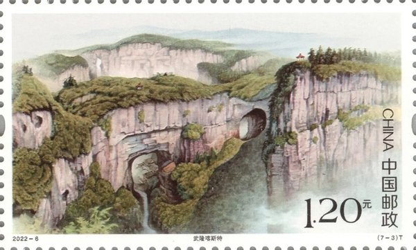
The Wulong karst
Chinese Scenery Stamps: World Natural Heritage – South China Karst (2022-6)

