

Contents
Overview
| Name | Li River 漓江 |
| Web address | https://parkofchina.com/en/liriver.html |
| Designation | UNESCO World Heritage (natural, 2014): the Guilin Karst, part of “South China Karst”, lies within the area National Park of China (first batch) AAAAA tourist attraction |
| Location | Guilin, Guangxi |
| Rivers and lakes | Li River |
| Highlights | Karst peak clusters and peak forest, river scenery, caves |
| Top sights | Nine Horses Fresco Hill, Huangbu Shoal, Xingping, Yangshuo, Yulong River |
| Coordinates | 24.96, 110.49 Google Maps |
| Nearby cities | Yangshuo County ⊙, Xingping Town ⊙, Guilin ↖︎21km, Hechi ←︎240km |
| Nearby airports | Guilin Liangjiang International Airport ←︎40km |
| Nearby sites | Guilin ↖︎20km, Mount Lang (Langshan) ↑︎143km, Jiuyi Mountain and Mausoleum of Emperor Shun →︎152km, West Mountain of Guiping ↓︎160km, Liping Dong Villages ↖︎177km |
| Themes | Karst, Mountain, Peak, Low Mountain, Cliff, River, Cave, Hidden River, Old bridges, Rafting & boat trips, Stamp, Banknote |
About
The Li River scenic area in north-eastern Guangxi Zhuang Autonomous Region centres on the Li River and the karst peak clusters and peak forest along its banks; its finest part is the stretch from Guilin city to Yangshuo, known for “green hills, clear water, strange caves, beautiful rocks”. As the saying every Chinese knows puts it, “Guilin’s scenery is the finest under heaven, and Yangshuo’s the finest in Guilin.” Its official name is the Guilin Lijiang scenic area, and it is a first-batch national park of China; the “Guilin landscape” was named by the China Tourism News one of China’s ten great scenic wonders. Two sections within it, Putao Fenglin and Lijiang Fengcong, form the Guilin Karst of the World Natural Heritage Site “South China Karst”. Elephant Trunk Hill, Seven Star Cave, Reed Flute Cave, the Princes’ City and other sights of Guilin city are on the Guilin page.
The Li River flows south past Guilin and Yangshuo, becomes the Gui River below Pingle and joins the Xi River at Wuzhou. Between Guilin and Yangshuo its banks are crowded with peaks and the water often winds right against the cliffs: “water winding round green hills, hills floating on green water”.


Places on the map: Guilin 桂林 B2, Elephant Trunk Hill 象鼻山 B2, Reed Flute Cave 芦笛岩 A1/B1, Daxu 大圩 E4, Mopanshan Pier 磨盘山码头 E5, Caoping 草坪 E7, Yangdi 杨堤 E8, Xingping 兴坪 G10, Yangshuo 阳朔 F13/F14, Crown Cave 冠岩 E7, Nine Horses Fresco Hill 九马画山 F10, Banknote view (20 yuan) 人民币背景 G10, Qianli Jiangshan viewpoint 千里江山 D10/D11, Putao Fenglin 葡萄峰林 C10, Lijiang Fengcong 漓江峰丛 E8, 黄布滩(黄布倒影) 黄布滩(黄布倒影) F11, 兴坪古镇 兴坪古镇 F11/G11, 遇龙河(遇龙桥) 遇龙河(遇龙桥) B15, 月亮山 月亮山 E18, 大榕树 大榕树 E18, 浪石 浪石 D9, 桂林市区(图外) 桂林市区(图外) A1, 千里江山观景点 千里江山观景点 B11/C11.
Map © Park of China · © OpenStreetMap contributors · terrain © Copernicus · Map credits
It is in the first batch of national parks of China (national scenic areas) named by the State Council in 1982.
Main sights
Guanyan (Crown Cave): in the Caoping area upstream on the Li River, a cave with an underground river that visitors enter by boat, emerging onto the Li River.
Yangdi: in the middle stretch of the Li River, where bamboo groves and karst peaks meet the bank. Short bamboo-raft rides run from here to Xingping.
Nine Horses Fresco Hill: on the river between Yangdi and Xingping, a cliff several hundred metres high whose colours and markings resemble a herd of galloping horses. It is one of the best-known views on the river.
Huangbu Shoal: just below Nine Horses Fresco Hill, where a pale yellow slab of rock lies on the riverbed; in the clear, shallow water the peaks on both banks are mirrored, a view called the “Huangbu reflections”.
Xingping: an old river town in the north of Yangshuo County and a national historic and cultural town; the view on the back of the fifth-series 20-yuan note is nearby, and cruise boats and bamboo rafts often stop here.
Yulong River: a tributary of the Li River in Yangshuo with gentle water, farmland and tower karst on both sides, used for bamboo rafts and cycling, with old bridges such as Yulong Bridge.

Places on the map: Elephant Trunk Hill 象鼻山 E7, Seven Star Cave 七星岩 G6, Reed Flute Cave 芦笛岩 B1/B2, Solitary Beauty Peak–Princes’ City 独秀峰·王城 E5/F5, Fubo Hill 伏波山 F5, Diecai Hill 叠彩山 F4, Sun and Moon Pagodas 日月双塔 E6/E7, Camel Hill 骆驼山 G7, Guilin Railway Station 桂林站 D8, Rong Lake 榕湖 D6, Shan Lake 杉湖 E6, Gui Lake 桂湖 E5, Mulong Lake 木龙湖 F4, Mulong Pagoda 木龙塔 F4, Sarira Pagoda 舍利塔 E7.
Map © Park of China · © OpenStreetMap contributors · terrain © Copernicus · Map credits
Yangshuo
Yangshuo town lies on the west bank of the Li River at the end of the cruise, surrounded by tower karst rising from the plain; sights include the Yulong River, Moon Hill and the Big Banyan Tree, and Silver Cave in neighbouring Lipu is often visited together with Yangshuo.
Local food
The famous dish along the Li River is beer fish, best known around Yangshuo: river fish cooked with beer, chili, tomato, ginger and so on, tender and mildly spicy; tianluo niang is snail meat chopped and mixed with pork, stuffed back into the shell and steamed or simmered. The taro from neighbouring Lipu is often made with pork belly into Lipu taro with pork. Guilin rice noodles are described on the Guilin city page.

Travel tips
Getting there: Guilin city and Yangshuo both have high-speed stations, and buses run between them; the airport is Guilin Liangjiang International Airport.
Li River cruise: boats leave from Mopanshan and other piers on the outskirts of Guilin and go downstream to Yangshuo in about four to five hours.
Bamboo rafts: short raft trips run between Yangdi and Xingping.
Yangshuo: on the Yulong River you can take a bamboo raft or cycle along the bank; nearby are the Big Banyan Tree, Moon Hill and Silver Cave.
Time: two days for the Li River cruise and Yangshuo; for the sights of Guilin city see Guilin.
Season: April to October has enough water; in dry spells the cruise may be shortened or suspended. Summer is hot and rainy, and floods stop both the boats and the rafts.
Caution: touts along the river and in Yangshuo sell raft rides and day tours that may be unlicensed; book through official channels.
Geology and landscape
The hills around Guilin are limestone of the Devonian to Carboniferous periods, laid down in a shallow sea more than 300 million years ago. After the land was uplifted, surface water and groundwater dissolved the limestone over a long time, leaving the present peaks, caves and underground rivers.
Karst landforms here take two shapes: clusters of peaks joined at the base (fengcong, peak clusters) and separate towers rising from a flat plain (fenglin, peak forest). Both appear on the plain from Guilin to Yangshuo, and the Li River winds among them, often right against the cliffs.
Stalactites, stalagmites and columns in the caves are deposited by water drops carrying calcium carbonate over a long time; Reed Flute Cave and Seven Star Cave in Guilin city and the caves around Yangshuo and Lipu formed in this way. In 2014 the Guilin Karst was inscribed on the World Heritage List as part of the second phase of South China Karst, in two sections: Putao Fenglin (Putao peak forest), around Putao in the north of Yangshuo County, where the peaks stand one by one on the flat ground, a classic peak forest; and Lijiang Fengcong (Li River peak clusters), on both banks of the middle Li River, about eight times as large, where clustered peaks joined at the base line the river and the cruise boats pass between them.
The Li River rises around Mao’er Mountain in Xing’an County, about 2,140 m high and one of the highest peaks in southern China. Xing’an County also has the Lingqu Canal, dug in the Qin dynasty, which links the Xiang River with the Li River and so joins the Yangtze and Pearl river systems.
Stamps
On 30 August 1980 China Post issued T53 “Guilin Landscape”, eight stamps: Pearl Cave and Sword Rock, three hills from afar, Nine Horses Fresco Hill, old banyan and egrets, sunset on the West Hill, moonlit Li River, waterfall and old ferry, and the scenery of Yangshuo.

Pearl Cave and Sword Rock 
Three hills from afar 
Nine Horses Fresco Hill 
Old banyan and egrets 
Sunset on the West Hill 
Moonlit Li River 
Waterfall and old ferry 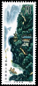
The scenery of Yangshuo
The 16th stamp of the 1981 definitive set Pu21 “Scenery of the Motherland” shows the Guilin landscape.

The Guilin landscape
On 25 February 2006 China Post issued 2006-4 “The Li River”, four stamps: Yangdi, Langshi, Huangbu and Xingping.

Yangdi 
Langshi 
Huangbu 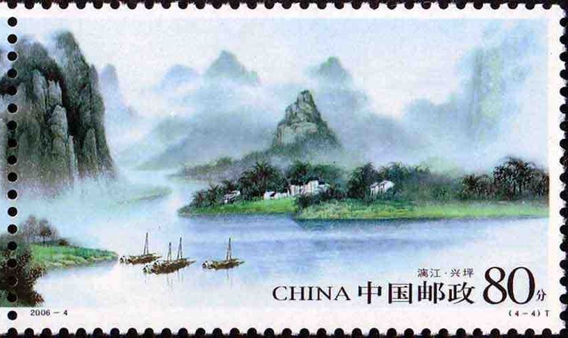
Xingping
The fourth stamp of the 2022 set 2022-6 “World Natural Heritage – South China Karst” shows the Guilin karst. The full set is on the South China Karst page.

The Guilin karst
Chinese Scenery Stamps: Guilin Landscape (T53), Scenery of the Motherland Definitives (Engraved) (Pu21), Li River (2006-4), World Natural Heritage – South China Karst (2022-6)
Banknotes
See also: Scenery on Chinese Banknotes
The back of the 20-yuan note of the fifth series of renminbi shows the Li River near Xingping, Yangshuo.

Classical Chinese texts
The texts, in Chinese, are in the Library of Chinese Literature.
- 郦道元 Li Daoyuan: 《水经注·漓水(漓江)》(节选)
- 杜甫 Du Fu: 《寄杨五桂州谭》
- 柳宗元 Liu Zongyuan: 《桂州裴中丞作訾家洲亭记》
- 韩愈 Han Yu: 《送桂州严大夫》
- 王正功 Wang Zhenggong: 《大比宴享即席劝驾诗(其二)》
- 范成大 Fan Chengda: 《桂海虞衡志·志岩洞》(节选)
- 王士性 Wang Shixing: 《广志绎·桂林山水》(节选)
Nearby
| Located in | Guangxi |
| World Heritage | Langshan ↑︎143km |
| National parks | Nanshan Scenic Area ↑︎120km, Mount Wanfo and the Dong Villages ↖︎135km, Jiuyi Mountain and Mausoleum of Emperor Shun →︎152km, West Mountain of Guiping ↓︎160km, Liping Dong Villages ↖︎177km, Rongjiang: Miao Mountains and Dong Waters ↖︎211km, Star Lake, Zhaoqing (Seven Star Crags, Mount Dinghu) ↘︎276km |
| Detailed guides | Guilin ↖︎20km, Huanjiang Karst ←︎245km |
| Cities | Liuzhou, Guangxi ↙︎121km |
| Airports | Guilin Liangjiang International Airport ←︎40km |
| AAAAA attractions | Elephant Trunk Hill ↖︎19km, Two Rivers and Four Lakes ↖︎20km, Huangyao Ancient Town Scenic Area ↘︎92km |
| Short guides | Lingqu Canal, Xing'an, Guangxi ↗︎56km, Longsheng Longji Terraces ↖︎76km |
| Historic towns | Xingping Town ⊙, Fuli Town →︎5km, Daxu Town ↑︎7km, Gongcheng Town →︎32km |
| AAAA attractions | Yangshuo West Street ⊙, Crown Cave Scenic Area ⊙, Yangshuo Sanqianli Chinese Landscape and Humanities Resort ⊙, Xiaoyao Lake →︎3km, Butterfly Spring ↓︎4km, Yuzi Leyuan Art Park ←︎10km, Yangshuo Fairyland Tourism Area ←︎12km, Guilin Hongxi ←︎14km |
| Historical sites | Fuziyan Site ↖︎10km, Zengpiyan Site ↖︎17km, Guilin Stone Carvings ↖︎19km, Prince of Jingjiang's Mansion and Tombs ↖︎20km |
| Nature reserves | Qichong National Nature Reserve ↘︎62km, Mao'ershan National Nature Reserve ↑︎80km, Huaping National Nature Reserve ↙︎84km, Qianjiadong National Nature Reserve →︎89km, Yongzhou Dupangling National Nature Reserve →︎94km |
| Historic villages | Jiuxian Village ←︎7km, Datian Village ↘︎48km |
Photo credits: Beer fish: Filipe Fortes (CC BY-SA 2.0, Wikimedia Commons)