 Park of China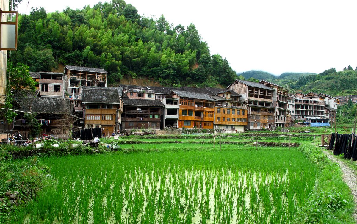
Overview
| Designation | National Park of China (fifth batch) |
| Province | Guizhou |
| Location | Liping County, south-east Guizhou |
| Latitude, longitude | 26.2, 109.1 Google Maps |
| Highlights | Karst |
| Nearby cities | Liping (Guizhou), Guilin (Guangxi) |
| Nearby sites | Wuyang River 121km, Mount Lang (Langshan) 171km, Libo and the Zhangjiang River 173km, Fanjingshan 193km, Guilin and the Li River 194km Search nearby |
| Themes | Karst, River, Arch, Stamp, Cave, Culture, Old villages & vernacular houses, Ethnic cultures, Old bridges |
About
The Liping Dong Villages scenic area in Liping County, south-east Guizhou, has three parts: the Bazhou River scenery, the historic sites of the county town and the Dong customs of Zhaoxing. It includes the drum towers of Zhaoxing, the largest Dong settlement in China, and the famous Diping wind-and-rain bridge.
The Bazhou River area around Gaotun township, 16 km north-east of the county seat, is karst, with Xianren Rock, the Shaozhai caves, Osmanthus Terrace, Luci Rack and a river island.
The Liping natural bridge, 1 km south-east of Gaotun, spans 104 m, is 118 m wide and 33 m above the river, with a rock layer about 40 m thick over the arch.
Xianren Rock on the river bank about 3 km from Gaotun has four stones standing on top and a cave of about 800 m² at its foot. Osmanthus Terrace on the east bank is 40 m high with hundreds of wild osmanthus trees.
It is in the fifth batch of national parks of China (national scenic areas) named by the State Council in 2004.
Travel tips
Getting there: Liping has its own airport. From Guiyang or Guilin, take a train to Congjiang or Rongjiang and change to a bus, or take a long-distance bus to Liping, about four to five hours. Zhaoxing is about 70 km from Liping, around an hour and a half by bus.
Layout: three parts, namely the Bazhou River scenery at Gaotun town, the historic sites in Liping town, and the Dong village area at Zhaoxing.
Zhaoxing: a very large Dong village with five drum towers and covered bridges, paved lanes you can walk, and song and dance performances in the evening.
Diping: the Diping wind-and-rain bridge is the best known, a timber covered bridge over a stream.
Bazhou River: northeast of Liping town, 16 km from it, with karst scenery such as a natural bridge and the Immortal Rock.
Time: a night at Zhaoxing and half a day in the village; add the Bazhou River and the town and you need two to three days.
Season: spring and autumn are pleasant. Dong festivals are held around the lunar new year, and the hills are cold in winter.
Where to stay: wooden guesthouses in Zhaoxing are the most convenient; Liping town also has hotels.
Caution: the hills see a lot of rain and the roads wind. The drum towers and bridges are used daily by villagers, so be considerate when visiting.
Stamps
On 22 June 1997 China Post issued 1997-8 “Dong Architecture”, four stamps: the Zengchong and Bai’er drum towers and wind-and-rain bridges over a river and among fields.
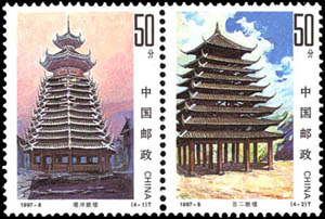

Photo credits: Zhaoxing Dong village: Rutger van der Maar (CC BY 2.0, Wikimedia Commons)
Nearby
| World Heritage | Wuyang River 121km, Shibing Karst (Yuntai Mountain) 147km, Huanjiang Karst 160km, Mount Lang (Langshan) 171km |
| National parks | Rongjiang: Miao Mountains and Dong Waters 69km, Mount Wanfo and the Dong Villages 74km, Nanshan Scenic Area 99km, Nine Dragon Cave 163km |
| AAAAA attractions | Chengyang Eight Villages Scenic Area 64km, Zhenyuan Ancient Town Scenic Area 116km, Two Rivers and Four Lakes 157km, Solitary Beauty Peak and Prince Jingjiang's Palace Scenic Area 157km |
| AAAA attractions | Liping Qiao Street 5km, Zhaoxing Dong Culture Tourist Scenic Area 33km, Turning Point Memorial Site Scenic Area 54km |
| Historical sites | Site of the Liping Conference 5km, Shudong Single-Pillar Drum Tower 21km, Longli Historic Building Complex 25km |
| Nature reserves | Yuanbaoshan National Nature Reserve 88km, Leigongshan National Nature Reserve 92km, Jiuwanshan National Nature Reserve 103km, Mao'ershan National Nature Reserve 136km |
| Historic villages | Zhaoxingzhai Village 33km |