 Park of China
Overview
| Name | Tianmen Mountain 天门山 |
| Web address | https://parkofchina.com/en/tianmenshan.html |
| Designation | National 5A Tourist Attraction (2011, listed together with Wulingyuan as the Zhangjiajie Wulingyuan–Tianmen Mountain Tourist Area); national forest park |
| Province | Hunan |
| Location | Yongding District, Zhangjiajie, Hunan; just south of the city |
| Latitude, longitude | 29.05, 110.48 Google Maps |
| Highlights | Limestone mountain, the natural arch Tianmen Cave, long cableway, winding road, cliff walkways |
| Top sights | Tianmen Cave, Tongtian Avenue, Tianmen Mountain cableway, cliff walkways, Tianmen Mountain Temple |
| Nearby cities | Zhangjiajie (Hunan) |
| Nearby sites | Wulingyuan (Zhangjiajie), Mengdong River, Peach Blossom Land (Taohuayuan), Meishan Dragon Palace, Ziquejie Terraces |
| Themes | Mountain, Middle Mountain, Peak, Arch, Cliff, Cable Car, Scenic drives, Forest |
Map
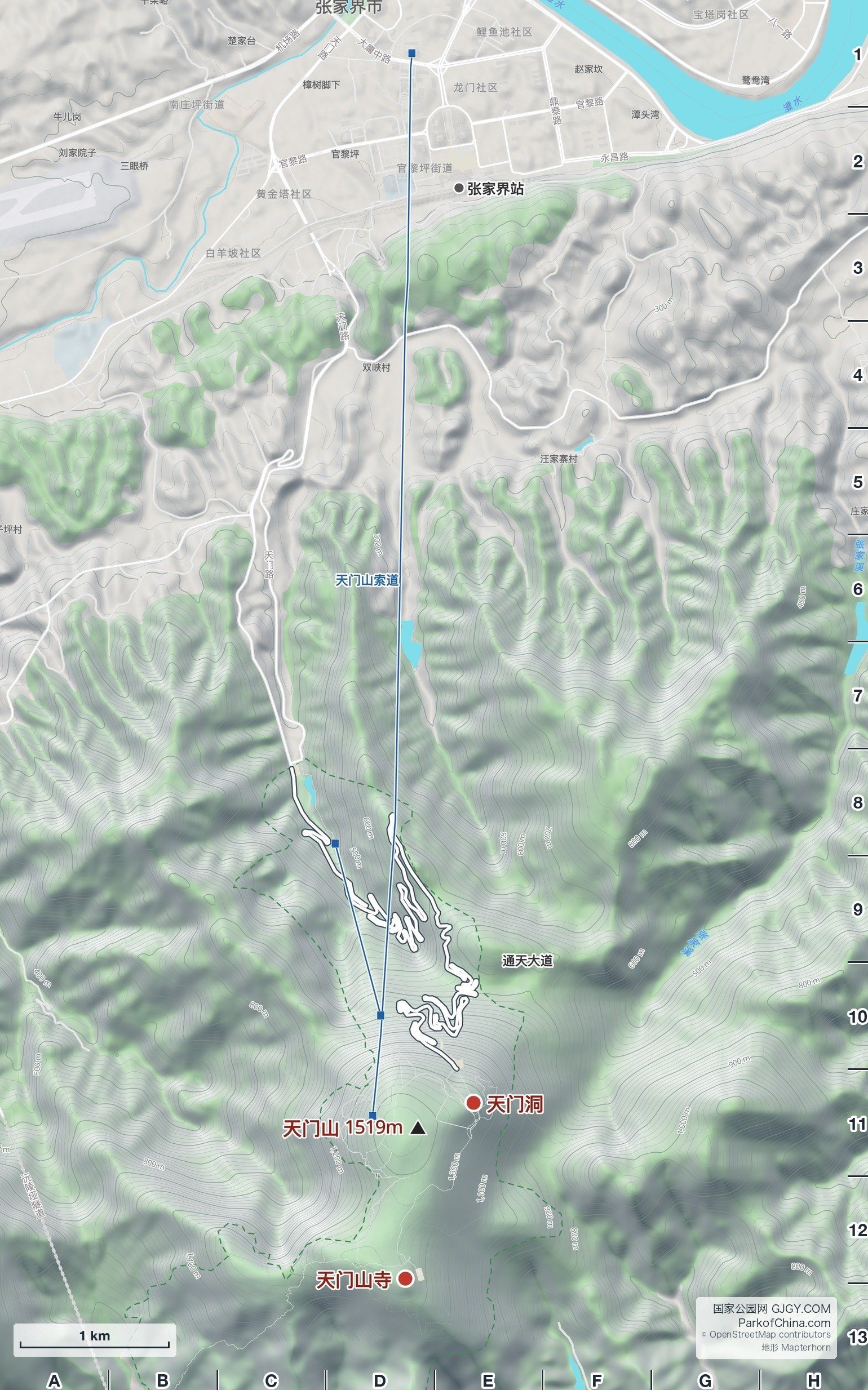
Places on the map: Tianmen Mountain 天门山 D11, Tianmen Cave 天门洞 E11, Tianmen Mountain Temple 天门山寺 D12/D13, Zhangjiajie Station 张家界站 E2, Tianmen Mountain cableway 天门山索道 D1–D11, Tianmen Cave express cableway 天门洞快线索道 D8–D10, Tongtian Avenue 通天大道 E9/E10.
© OpenStreetMap contributors · terrain © Copernicus · Map credits
About
Tianmen Mountain rises just south of Zhangjiajie city in Hunan. At about 1,519 m it is the highest mountain near the city. It lies about 30-odd km from Wulingyuan to the north, and the two are listed together as a National 5A Tourist Attraction, but Tianmen Mountain is not part of the Wulingyuan World Heritage Site and its landscape is different: Wulingyuan is a forest of sandstone pillars, while Tianmen is a limestone massif ringed by cliffs, with a fairly flat, densely wooded top.
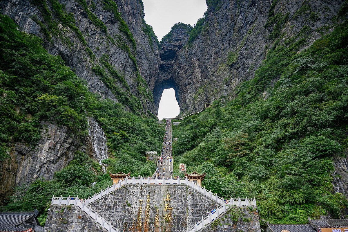
High on the northern cliffs, facing the city, is a huge natural arch, Tianmen Cave ("Heaven's Gate"), more than 100 m tall and open from north to south, so that from a distance it looks like a door in the mountain. Historical records say that in 263, under the state of Wu in the Three Kingdoms period, the cliff collapsed and the opening appeared; the Wu ruler Sun Xiu took it as a good omen, renamed the mountain, until then called Songliang, as Tianmen Mountain, and set up Tianmen Commandery.
There are two ways up. The Tianmen Mountain cableway runs from the city to the summit; at more than 7 km it is one of the longest passenger cableways in the world. The other is the winding road known as Tongtian Avenue, which climbs the slope in ninety-nine bends to the foot of Tianmen Cave; from the end of the road a flight of more than 900 steps, the "Stairway to Heaven", or escalators inside the mountain lead up to the cave.
On the summit, walkways run along the cliff edge, some sections with glass floors looking down hundreds of metres; Tianmen Mountain Temple is on the west side.
Travel tips
Getting there: the lower cableway station is in Zhangjiajie city, not far from Zhangjiajie railway station; from Wulingyuan it is about an hour by road.
Visiting: most people take the cableway up, walk the summit cliff paths and visit the temple, then take the park bus down Tongtian Avenue to Tianmen Cave, and finally ride down the mountain; the route can also be done in reverse. Allow a full day.
Caution: the summit is much colder than the city and often in cloud; on holidays the queues for the cableway are long. The glass walkways and the steps to Tianmen Cave are not for those afraid of heights.
Related sites
Nearby
| World Heritage | Wulingyuan (Zhangjiajie) 34km, Laosicheng Site 53km, Tangya Tusi Chengzhi 160km, Fanjingshan 218km |
| National parks | Mengdong River 60km, Peach Blossom Land (Taohuayuan) 96km, Dehang 107km, Liye and Wulong Mountain 129km |
| Detailed guides | Meishan Dragon Palace 145km |
| AAAAA attractions | Zhuoshui Scenic Area 169km, Youyang Peach Blossom Spring Scenic Area 169km, Changyang Qingjiang Gallery Scenic Area 170km, Enshi Grand Canyon Scenic Area 196km |
| AAAA attractions | Zhangjiajie Tusi City 9km, Baofeng Lake 31km, Zhangjiajie Grand Canyon 45km, Departure Site of the Long March of the Second Front Army of the Chinese Workers' and Peasants' Red Army 52km |
| UNESCO Global Geoparks | Xiangxi UNESCO Global Geopark 76km, Enshi Grand Canyon-Tenglongdong Cave UNESCO Global Geopark 183km |
| Historical sites | Tian Family Compound 8km, Sites of the Hunan-Hubei-Sichuan-Guizhou Revolutionary Base 9km |
| National geoparks | Hongshilin National Geopark 71km, Wufeng National Geopark 125km, Fenghuang National Geopark 148km |
| Nature reserves | Baiyunshan National Nature Reserve 25km, Yingzuijie National Nature Reserve 31km, Xiaoxi National Nature Reserve 35km, Jiemuxi National Nature Reserve 44km |