 Park of China
Overview
| Designation | National Park of China (first batch) AAAAA tourist attraction |
| Province | Guangxi |
| Location | Northern Guangxi |
| Rivers and lakes | Li River |
| Latitude, longitude | 25.0, 110.5 Google Maps |
| Highlights | Karst landscape, peak forests, caves |
| Top sights | The Li River, Yangshuo, Elephant Trunk Hill |
| Nearby cities | Guilin, Liuzhou |
| Nearby sites | Jiuyi Mountain and Mausoleum of Emperor Shun 156km, Mount Lang (Langshan) 164km, West Mountain of Guiping 181km, Liping Dong Villages 194km Search nearby |
| Themes | Karst, Mountain, Peak, River, Cave, Stamp, Banknote, Rafting & boat trips, Food |
About
The Guilin and Li River scenic area in northern Guangxi is known for its karst peaks, rivers and caves: “green hills, clear water, strange caves, beautiful rocks”. It is a first-batch national park of China; in 1985 the China Tourism News named the Guilin landscape one of China’s ten great scenic wonders, and in 1982 Guilin was in the first batch of Historic and Cultural Cities.
Main sights
Elephant Trunk Hill: in central Guilin where the Li and Taohua rivers meet. The hill looks like an elephant dipping its trunk into the river, and a hole through it, Water Moon Cave, is the emblem of the city.
Fubo Hill: on the west bank of the Li River, its foot reaching into the water. Returned Pearl Cave at its base holds inscriptions and Buddhist carvings dating from the Tang and Song periods.
Diecai Hill: in the north of the city on the west bank. Its layered slopes are likened to folded silk, Wind Cave on the hillside has many cliff inscriptions, and the summit overlooks the city and river.
Solitary Beauty Peak and the Prince of Jingjiang's Palace: in the city centre, the peak stands alone on the flat ground. The Ming-dynasty palace of the Princes of Jingjiang is now part of a university campus, and the peak can be climbed for a view.
Guanyan (Crown Cave): in the Caoping area upstream on the Li River, a cave with an underground river that visitors enter by boat, emerging onto the Li River.
Yangdi: in the middle stretch of the Li River, where bamboo groves and karst peaks meet the bank. Short bamboo-raft rides run from here to Xingping.
Nine Horses Fresco Hill: near Huangbu Shoal on the lower river, a cliff several hundred metres high whose colours and markings resemble a herd of galloping horses. It is one of the best-known views on the river.
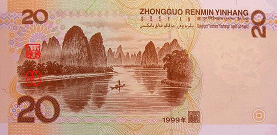
Xingping: an old river town in the north of Yangshuo County, near the view shown on the back of the 20-yuan banknote. It is a common end point for river cruises.
Yulong River: a tributary of the Li River in Yangshuo with gentle water, farmland and tower karst on both sides, used for bamboo rafts and cycling, with old bridges such as Yulong Bridge.
Longji Terraces: in Longsheng Autonomous County to the northwest of Guilin, layered rice terraces on hillsides, with viewpoints at Ping'an and Jinkeng. Most villagers are Zhuang and Yao.
Reed Flute Cave: in Guangming Hill north-west of the city, about 240 m deep with a 500 m visitor route; its walls keep more than 70 ink inscriptions, the earliest from 792 in the Tang dynasty.
Seven Star Cave: inside Putuo Hill in Seven Star Park, known in the past as Qixia Cave. The middle level open to visitors is up to 43 m wide and 27 m high, with an 814 m route and a steady 20 °C; it has drawn visitors since the Tang dynasty.
Jingjiang Princes' Tombs: at the southwest foot of Yao Shan on the eastern outskirts, the Ming-dynasty cemetery of the Princes of Jingjiang and their clan, with 11 princely tombs (one for a posthumously titled prince) and over 300 tombs of clan members and relatives; many stone guardian figures survive.
On top of Elephant Trunk Hill stands the Puxian Pagoda, a solid Ming-dynasty brick pagoda in Tibetan style about 13.6 m high, set with an engraved image of the bodhisattva Samantabhadra; Water Moon Cave holds more than 50 inscriptions, mostly from the Song dynasty.
Geology and landscape
The hills around Guilin are limestone of the Devonian to Carboniferous periods, laid down in a shallow sea more than 300 million years ago. After the land was uplifted, surface water and groundwater dissolved the limestone over a long time, leaving the present peaks, caves and underground rivers.
Karst landforms here take two shapes: clusters of peaks joined at the base (fengcong, peak clusters) and separate towers rising from a flat plain (fenglin, peak forest). Both appear on the plain from Guilin to Yangshuo, and the Li River winds among them, often right against the cliffs.
Stalactites, stalagmites and columns in the caves are deposited by water drops carrying calcium carbonate over a long time. The Reed Flute Cave and Seven Star Cave in Guilin, and caves around Yangshuo and Lipu, formed in this way. In 2014 Guilin's karst landscapes were inscribed on the World Heritage List as part of the second phase of South China Karst.
The Li River rises on Mao'er Mountain north of Guilin, about 2,140 m high and one of the highest peaks in southern China, and its water eventually joins the Xi River. In Xing'an County, north of Guilin, the Lingqu Canal, dug in the Qin dynasty, links the Xiang River with the Li River and so joins the Yangtze and Pearl river systems.
Travel tips
Getting there: Guilin Liangjiang International Airport and the high-speed stations Guilin North and Guilin West all connect with the city; Yangshuo has its own high-speed station, and buses run between Guilin and Yangshuo.
Li River cruise: boats leave from Mopanshan and other piers on the outskirts of Guilin and go downstream to Yangshuo in about four to five hours. Tickets are sold under your real name with ID; book ahead in peak season.
Bamboo rafts: short raft trips run between Yangdi and Xingping; the view near Xingping is the one on the back of the 20-yuan note.
Guilin city: Elephant Trunk Hill, Fubo Hill, Diecai Hill, Seven Star Park and Reed Flute Cave are close together and fit into one day; in the evening boats tour the Two Rivers and Four Lakes.
Yangshuo: on the Yulong River you can take a bamboo raft or cycle along the bank; nearby are the Big Banyan Tree, Moon Hill and Silver Cave.
Time: two days for the Li River and Yangshuo, one day for Guilin city; the Longji rice terraces need another day.
Season: April to October has enough water; in dry spells the cruise may be shortened or suspended. Summer is hot and rainy, and floods stop both the boats and the rafts.
Caution: touts along the river and in Yangshuo sell raft rides and day tours that may be unlicensed; book through official channels.
Guilin city
The city’s highlights are “three hills and two caves”: Elephant Trunk Hill, Fubo Hill, Folded Brocade Hill, Reed Flute Cave and Seven Star Cave in Seven Star Park. The park also has the famous Camel Hill. Cliff carvings and inscriptions are found on Fubo Hill and in the Wind Cave of Folded Brocade Hill.
The city’s waterscape is the “two rivers and four lakes”: the Li and Taohua rivers and Rong, Shan, Gui and Mulong lakes.
The Li River
The Li rises in Xing’an County and flows south through Guilin and Yangshuo; below Lipu it becomes the Gui River and joins the West River at Wuzhou, 426 km in all. Between Guilin and Yangshuo its banks are crowded with peaks, “water winding round green hills, hills floating on green water”, the heart of the scenic area; the most famous sight is the Nine Horses Fresco Hill.
Yangshuo
“Guilin’s scenery is the finest under heaven, and Yangshuo’s the finest in Guilin.” Yangshuo is even lovelier than Guilin and many foreigners have settled there. Its sights include the Big Banyan, Silver Cave and Moon Hill.
Banknotes and stamps
The back of the 20-yuan note of the fifth series of renminbi shows the Li River at Xingping, Yangshuo.
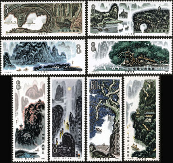
On 30 August 1980 China Post issued T53 “Guilin Landscape”, eight stamps: Pearl Cave and Sword Rock, three hills from afar, Nine Horses Fresco Hill, old banyan and egrets, sunset on the West Hill, moonlit Li River, waterfall and old ferry, and the scenery of Yangshuo.
On 25 February 2006 2006-4 “The Li River”, four stamps: Yangdi, Langshi, Huangbu and Xingping.

The 16th stamp of the 1981 definitive set R21 “Scenery of the Motherland” shows Guilin.

Climate
Guilin has a humid subtropical monsoon climate, mild and rainy, with rain and heat in the same season: “little snow in winter, flowers all year”. The annual mean is about 19 °C; summers are hot, occasionally above 40 °C, winters around freezing with almost no snow. The frost-free period is 309 days and annual rainfall 1,926 mm, as in the saying “foggy Chongqing, rainy Guilin”. In the plum-rain season summer downpours bring muggy weather, swollen rivers and frequent floods.
Food
Guilin rice noodles. The “three treasures of Guilin”: chilli sauce, fermented bean curd and Sanhua liquor.
Suggested itinerary
Day 1: cruise down the Li River to Yangshuo and spend half a day there. Day 2: the three hills and two caves in Guilin.
Map
Photo credits: The Li River: chensiyuan (CC BY-SA 4.0, Wikimedia Commons)
Nearby
| World Heritage | Guilin Karst - Putao Fenling Karst Section 11km, Mount Lang (Langshan) 164km, Huanjiang Karst 249km, Libo and the Zhangjiang River 277km |
| National parks | Nanshan Scenic Area 141km, Mount Wanfo and the Dong Villages 155km, Jiuyi Mountain and Mausoleum of Emperor Shun 156km, West Mountain of Guiping 181km |
| AAAAA attractions | Elephant Trunk Hill 38km, Two Rivers and Four Lakes 40km, Solitary Beauty Peak and Prince Jingjiang's Palace Scenic Area 40km, Huangyao Ancient Town Scenic Area 108km |
| AAAA attractions | Lishui Renjia 8km, Crown Cave Scenic Area 10km, Xiaoyao Lake 18km, Yangshuo West Street 20km |
| Historic cities | Guilin 39km |
| Historical sites | Fuziyan Site 29km |
| National geoparks | Ziyuan National Geopark 122km |
| Nature reserves | Qichong National Nature Reserve 81km, Qianjiadong National Nature Reserve 96km, Huaping National Nature Reserve 100km, Yongzhou Dupangling National Nature Reserve 100km |
| Historic towns | Xingping Town 8km, Fuli Town 21km, Daxu Town 28km, Gongcheng Town 40km |
| Historic villages | Jiuxian Village 19km |