 Park of China
Overview
| Designation | UNESCO World Heritage (mixed, 1990) National Park of China (first batch) AAAAA tourist attraction |
| Province | Anhui |
| Location | Southern Anhui |
| Mountains | Mountain Ranges of China |
| Latitude, longitude | 30.1, 118.2 Google Maps |
| Highlights | Granite peaks, sea of clouds |
| Top sights | Shixin Peak, Tiandu Peak, the North Sea and West Sea of clouds |
| Area | 154 km² |
| Highest point | 1,865 m |
| Nearby cities | Huangshan (Tunxi) |
| Nearby sites | Ancient Villages in Southern Anhui 30km, Mount Jiuhua 49km, Qiandao Lake 125km, Mount Sanqing 136km, West Lake, Hangzhou 191km Search nearby |
| Themes | Famous Mountain, Mountain, Peak, Stone, Cliff, Geothermal, Small Waterfall, Taoism, Stamp, Cable Car, Sea of clouds & sunrise, Ancient trees, Hot springs, Hiking & climbing, Viewpoints & photography |
About
Huangshan, anciently called Yishan, lies in southern Anhui and heads the three great mountains of China; legend says the Yellow Emperor refined the elixir of immortality here. The Ming traveller Xu Xiake wrote: “After the Five Sacred Mountains you look at no other mountain; after Huangshan you look at no other sacred mountain.”
Huangshan’s “four wonders” are its strange pines, grotesque rocks, sea of clouds and hot springs. The three main peaks are Lotus Peak (1,864.8 m), Bright Summit (1,860 m) and Tiandu (Celestial Capital) Peak (1,810 m). Of the ten famous pines, the Guest-Greeting Pine below Jade Screen Peak is the best known.
Around Bright Summit and Lotus Peak is the “Heavenly Sea” of clouds, with the East, West, Front and Back Seas around it.
Huangshan was anciently called Yishan ("Black Mountain") for its dark rock; in 747, during the Tianbao era of the Tang, it was renamed Huangshan after the legend that the Yellow Emperor made elixirs here.
It was inscribed on the UNESCO World Heritage List in 1990, as a mixed site. It is in the first batch of national parks of China (national scenic areas) named by the State Council in 1982.
Main sights
Yupinglou and the Welcoming Pine: on the middle of the front mountain, Yupinglou stands on the slope near Wenshu Cave. The Welcoming Pine beside it extends a branch sideways like an arm greeting visitors, and is the symbol of Huangshan. It is reached on foot from the Yuping cable car.
Lotus Peak: the highest peak at 1,864.8 m, with open views from the summit. The route is steep, usually needs a booking, and is closed at times for maintenance.
Tiandu Peak: a steep peak on the front mountain. The path crosses the narrow Carp Back ridge with deep valleys on both sides, and steps and chains have been cut and fixed into the cliff.
Bright Summit Peak (Guangming Ding): the second highest peak at 1,860 m, with a flat, open top. It is a place to watch sunrise and the sea of clouds, and to the southwest the peaks of the West Sea can be seen.
Shixin Peak: on the back mountain, made of three stone peaks surrounded by cliffs, with many pines growing on the tops and in cracks in the rock. It is known for its pines and rocks.
North Sea and Qingliang Terrace: the centre of the back mountain, where most of the mountain's accommodation is. Qingliang Terrace is a place to watch sunrise and cloud, and the nearby rock pillar known as the Pen Blossoming Flowers appears on Huangshan stamps.
West Sea Grand Canyon: in the west of the mountain, a canyon with steep stone peaks on both sides and a path built along the cliff. Near Paiyun Pavilion, cloud and peaks can be seen.
Hot Spring area: at the south foot below Ziyun Peak, beside Taohua Stream. It is one of the starting points for climbing and the site of the mountain's hot springs, near Cigu Pavilion and the lower station of the Yuping cable car.
Monkey Gazing at the Sea: a rock in front of Lion Peak in the North Sea area, shaped like a squatting monkey looking over the clouds, also called Monkey Gazing at Taiping (the county to the north). Qingliang Terrace on the flank of Lion Peak is known as the first terrace of Huangshan.
Flying-Over Rock: at the west end of the Pingtiangang ridge west of Bright Summit, a slab of rock about 12 m high standing upright on a flat ledge with only a small contact at its base.
Geology and landscape
Huangshan is made mainly of granite, a body of magma that cooled underground about 100 million years ago and was later exposed as the crust rose.
The granite has nearly vertical joints. Weathering, frost and running water have worked along them, leaving steep peaks, rock pillars and cliffs. Well-known rock forms such as the Pen Blossoming Flowers and the Flying-Over Rock were formed in this way.
The Huangshan pine grows above about 800 m, with roots in cracks in the rock and branches mostly spread to one side. With strong winds and thin soil at the top the trees grow slowly, so they are short and irregular in shape.
The mountain carries traces left by Quaternary glaciers, such as cirques and glacial striations, showing that ice covered parts of it during the Ice Age.
Rainfall and humidity are high, and moisture condenses among the peaks into the sea of clouds. Foggy days are many through the year.
Travel tips
Getting there: Huangshan North station is served by high-speed trains; a bus to Tangkou, the town at the foot of the mountain, takes about an hour. Huangshan Tunxi Airport is nearby. The mountain can also be entered from the Taiping side to the north and from the East Gate.
Booking: tickets are booked in advance under your real name; places are tight in high season and on holidays, so book a few days ahead.
Going up: from Tangkou take a park bus to Ciguang Pavilion for the Yuping cable car, or to Yungu Temple for the Yungu cable car; the Taiping cable car serves the north side and the Donghai cable car the East Gate. Paths on the front and back of the mountain can also be walked.
Front mountain: the Welcoming Guest Pine stands by Yuping Lodge. The paths up Tiandu Peak and Lotus Peak are steep, and the two peaks take turns being closed for recovery; when Tiandu Peak is open, the climb needs its own booking. Check which is open.
Back mountain and the North Sea: Shixin Peak, the North Sea area and Lion Peak, with gentler paths. Bright Summit lies between the North Sea and Yuping Lodge.
West Sea Grand Canyon: a path up and down sheer cliffs with many steps, hard work; a funicular covers part of the way.
Time: two days and one night is comfortable; a night on the mountain lets you see sunrise and sunset.
Where to stay: there are hotels on the mountain around the North Sea, Bright Summit, West Sea and Yuping Lodge, with few rooms, so book early in high season; below, most people stay in Tangkou.
Caution: the weather changes quickly; summer brings rain and fog, and in winter the steps ice over. You carry your own luggage up, so travel light.
Stamps
In 1963 China Post issued a set of 16 stamps, “Huangshan”: Jade Screen Peak, the Guest-Greeting Pine, pines and rocks of the Back Sea, Qingliang Terrace, Tiandu Peak from afar, Scissors Peak, the Ten-Thousand Pine Forest, Flower Growing from a Dream Brush, Lotus Peak, cloud tide of the West Sea, ancient pines, cloud tide of the East Sea, Stone Bamboo Shoot Peak, Stone Monkey Watching the Sea, Lion Grove and the Three Isles of Penglai.

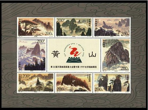
In 1997 a set of eight “Huangshan” stamps was issued: Huangshan at dawn, peaks of the West Sea, flying rock amid clouds, clouds over the North Sea, Jade Screen, Flower Growing from a Dream Brush, Tiandu Peak above the clouds and the Isles of Penglai.
The 17th stamp of the 1981 definitive set R21 “Scenery of the Motherland” shows Huangshan.

More photos

Map

Photo credits: Flower Growing from a Dream Brush, North Sea: 颐园新居 (CC BY-SA 4.0, Wikimedia Commons); Shixin Peak: Boule02de (CC BY-SA 3.0, Wikimedia Commons)
Nearby
| World Heritage | Ancient Villages in Southern Anhui: Xidi and Hongcun 30km, Jingdezhen Handicraft Porcelain Industry Sites 129km, Mount Sanqing 136km, Archaeological Ruins of Liangzhu City 178km |
| National parks of China | Wuyishan National Park 276km |
| National parks | Mount Qiyun 38km, Longchuan 48km, Huashan Mystery Caves and the Jian River 48km, Mount Jiuhua 49km |
| AAAAA attractions | Ancient Huizhou Cultural Tourist Area 38km, Wuyuan Jiangwan Scenic Area 85km, Huangling Scenic Area 90km, Kaihua Root Palace Buddhist Culture Tourist Area 113km |
| AAAA attractions | Pingshan Scenic Area 5km, Jiulongpu 6km, Feicuigu 6km, Furonggu 18km |
| UNESCO Global Geoparks | Changshan UNESCO Global Geopark 140km |
| Historic cities | Yi County 32km, She County 39km, Jixi County 42km |
| Historical sites | Huangshan Mountain Trails and Historic Buildings 3km, Huangshan Cliff Inscription Group 4km, Xingcun Cheng Clan Ancestral Hall 18km, She County Xu Family Ancestral Hall 21km |
| National geoparks | Fushan National Geopark 122km, Changshan National Geopark 140km |
| Nature reserves | Qingliangfeng National Nature Reserve 63km, Lin'an Qingliangfeng National Nature Reserve 78km, Wuyuan Forest Birds National Nature Reserve 81km, Chinese Alligator National Nature Reserve 104km |
| Historic towns | Xucun Town 21km, Xixinan Town 35km, Wan'an Town 38km, Taohuatan Town 39km |
| Historic villages | Lucun Village 23km, Chengkan Village 26km, Lingshan Village 28km, Xidi Village 30km |