 Park of China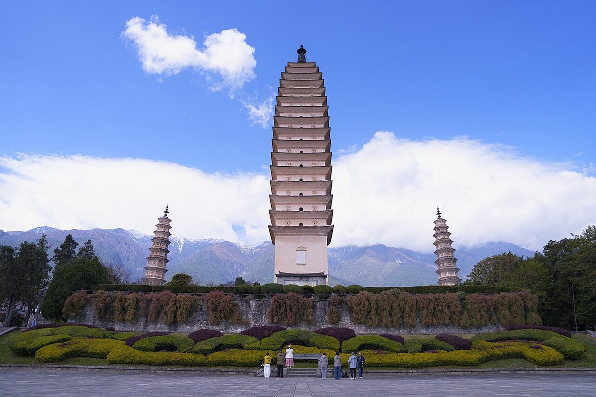
Overview
| Designation | National Park of China (first batch) |
| Province | Yunnan |
| Location | Dali Bai Autonomous Prefecture, western Yunnan |
| Mountains / Rivers and lakes | Yunling Mountains; Erhai Lake |
| Latitude, longitude | 25.7, 100.2 Google Maps |
| Nearby cities | Kunming |
| Highlights | Wind, flowers, snow and moon |
| Area | 1,016 km² |
| Elevation | 1,966 m |
| Highest point | 4,122 m |
| Nearby sites | Three Parallel Rivers of Yunnan 132km, Jade Dragon Snow Mountain and Lijiang 161km, Tengchong Geothermal Area and Volcanoes 191km Search nearby |
| Themes | Ancient City, Tower, Lake, Snow Mountain, Stamp, Mountain, Buddha, Ethnic cultures, Hot springs |
About
Dali, in the Bai Autonomous Prefecture of western Yunnan, lies at the foot of the Cangshan range on the shore of Erhai Lake and was the capital of the ancient Dali kingdom. It is famed for “wind, flowers, snow and moon”: the wind of Shangguan, the flowers of Xiaguan, the snow of Cangshan and the moon over Erhai.
The scenic area, 1,016 km², has five parts: Dali, Cangshan and Erhai; Shibao Mountain at Jianchuan; the Buddhist mountain Jizu; the Taoist temples and forest park of Weibao Mountain at Weishan; and the Cibi Lake hot springs. The main sights are the old town of Dali, Cangshan, Erhai, Butterfly Spring, the Three Pagodas of Chongsheng Temple, Jizu Mountain, the Shizhong Mountain grottoes, Weibao Mountain and the old town of Weishan.
The Three Pagodas of Chongsheng Temple date from the Nanzhao kingdom: the main pagoda is square and hollow, nearly 70 m, with 16 tiers of close-set eaves; the two smaller pagodas behind it on either side have 10 tiers and stand about 42 m.
Cangshan belongs to the Yunling range and is rich in plants; its summit, 4,122 m, is snow-capped all year. Butterfly Spring lies at the foot of its Yunshou Peak.
Erhai is an alpine freshwater lake at 1,966 m with three islands and four shoals. The largest island, Jinsuo in the east, is about 2 km long; the Nanzhao kings had a summer palace on it in the Tang dynasty.
Dali averages 15 °C with 1,056 mm of rain a year.
Erhai was known in ancient times as Yeyu Ze and also Kunmi Chuan and Xi'er He; it is about 42.6 km long, up to 9 km wide and about 20 m deep.
It is in the first batch of national parks of China (national scenic areas) named by the State Council in 1982.
Map

Main sights
Dali Old Town: a walled town built in the early Ming dynasty between the Cangshan range and the west shore of Erhai Lake. Gate towers and parts of the wall survive, and Bai houses with screen walls and ornate gateways line the lanes.
Three Pagodas of Chongsheng Temple: just north of the old town at the foot of the Cangshan, and the symbol of Dali. The main one, Qianxun Pagoda, dates from the Tang dynasty; the two smaller ones were built later.
Cangshan: a range about 50 km long with nineteen peaks and eighteen streams running down between them. The Jade Belt Road runs along the mid-slope past several valleys, with old temples scattered on the hillside.
Erhai Lake: a rift lake about 40 km long, named for its ear-like shape. Bai towns such as Xizhou and Zhoucheng lie on the west shore, and Shuanglang on the northeast shore sits on a peninsula reaching into the lake.
Xizhou: on the west shore about 20 km north of the old town, with many traditional Bai courtyard houses. The Yan and Dong family compounds show the typical 'three buildings and a screen wall' and 'four buildings, five courtyards' layouts.
Butterfly Spring: a spring pool at the foot of Yunnong Peak in the Cangshan. It appears in Xu Xiake's travel diary and became widely known through the 1959 film Five Golden Flowers.
Weishan Old Town and Weibao Mountain: about 60 km south of Dali. Weishan is the birthplace of the Nanzhao kingdom, with the Ming-period Gongchen and Xinggong towers; Weibao Mountain is a Daoist mountain with temples such as Qingxia Palace.
Jizu Mountain: in Binchuan County, a Buddhist mountain said to be where the disciple Mahakashyapa entered meditation. Its temples include Jinding and Zhusheng.
Shibao Mountain: in Jianchuan County, site of the Shizhongshan Grottoes, a group of rock-cut shrines made in the Nanzhao and Dali kingdom periods, with Buddhist figures and images connected with the Nanzhao court.
Qianxun Pagoda was built during the Nanzhao period and is 69.13 m tall; the screen wall east of it bears the four large characters Yong Zhen Shan Chuan.
Each spring and early summer butterflies gather on the tree over Butterfly Spring; Xu Xiake in 1639 described them hanging in chains from the treetop. The Bai hold a Butterfly Festival here on the 15th of the fourth lunar month. Butterflies are now far fewer than in the past.
History and culture
The Dali area has long been the centre of western Yunnan. In the Tang period the Nanzhao kingdom united the groups around Erhai Lake, with capitals first at Taihe and later at Yangjuemei, near the present old town, until 902.
In 937 Duan Siping founded the Dali Kingdom, still centred on Dali and in contact with the Song court. Buddhism flourished and several kings became monks. Mongol forces ended the kingdom in 1253, after which Yunnan's political centre moved east to Kunming.
The Bai are the main people of the Dali area, with their own language, dress and festivals. The March Fair, held in mid third lunar month, is a traditional market and festival said to be a thousand years old. The Bai serve guests 'three-course tea', which is bitter, then sweet, then lingering.
The typical Bai house is the 'three buildings and a screen wall': three buildings around a courtyard with a screen wall on the fourth side. Marble from the Cangshan gave 'dalishi', the Chinese word for marble, its name, and tie-dyeing is a traditional craft in villages such as Zhoucheng.
Travel tips
Getting there: high-speed trains run from Kunming to Dali in about two hours, and Dali has an airport. The station is at Xiaguan and the airport east of it; buses and taxis go on to the old town of Dali.
Dali old town and the Three Pagodas: the old town is best seen on foot. The Three Pagodas of Chongsheng Temple are a short way north; allow about half a day.
Erhai Lake: the shore is over 100 km round. Along the west shore an ecological corridor is open to cyclists and walkers but not to cars. Xizhou on the west shore and Shuanglang on the northeast shore are the villages most visited.
Cangshan Mountains: several cable cars go up, and a path along the mountainside (the Jade Belt Road) links them. Weather changes fast up high, and the cable cars stop in strong wind.
Jizu Shan and others: Jizu Shan is in Binchuan county, Shibao Shan in Jianchuan and Weibao Shan in Weishan, each a fair drive from Dali old town; each needs a day of its own.
Time: three to four days for the old town, the pagodas, Erhai and Cangshan.
Season: open all year. Winter and spring are sunny and windy; summer and autumn are the rainy season, mostly with showers.
Caution: Dali is about 2,000 m up. The sun is strong and mornings and evenings are cool; bring sun protection and a jacket.
Stamps
On 19 April 2000 China Post issued 2000-8 “Scenery of Dali”, four stamps: Cangshan and Erhai, the Three Pagodas, Jizu Mountain and Shibao Mountain.

The second stamp of the 1958 set S21 “Ancient Pagodas of China” shows the Qianxun Pagoda at Dali.

Photo credits: The Three Pagodas of Dali: Jackiejackie123123 (CC BY-SA 4.0, Wikimedia Commons)
Nearby
| World Heritage | Three Parallel Rivers of Yunnan 132km, Jade Dragon Snow Mountain and Lijiang 161km |
| National parks | Tengchong Geothermal Area and Volcanoes 191km |
| AAAAA attractions | Three Pagodas of Chongsheng Temple Cultural Tourist Area 1km, Lijiang Old Town Scenic Area 132km, Heshun Ancient Town Scenic Area 148km |
| AAAA attractions | Dali Prefecture Museum Scenic Area 13km, Dali Ocean World Scenic Area 16km, Dali Butterfly Spring Park 24km |
| UNESCO Global Geoparks | Dali-Cangshan UNESCO Global Geopark 14km |
| Historic cities | Weishan 54km, Jianchuan County 96km |
| Historical sites | Stele of Emperor Shizu of Yuan Pacifying Yunnan <1km, Dali Catholic Church 1km, Hongsheng Temple Pagoda 1km, Three Pagodas of Chongsheng Temple 1km |
| National geoparks | Dali Cangshan National Geopark 8km |
| Nature reserves | Cangshan–Erhai National Nature Reserve 15km, Yunlong Tianchi National Nature Reserve 89km, Wuliangshan National Nature Reserve 107km |
| Historic towns | Fengyu Town 40km, Zhoucheng Town 43km |
| Historic villages | Donglianhua Village 30km |