 Park of China
Overview
| Designation | US National Park |
| Location | Northern Ohio, USA |
| Latitude, longitude | 41.3, -81.6 Google Maps |
| Nearby sites | New River Gorge National Park 370km, Shenandoah National Park 391km, Indiana Dunes National Park 464km, Mammoth Cave National Park 597km Search nearby |
| Top sights | Brandywine Falls |
| Wildlife | Deer |
| Area | 33,000 acres |
| Nearby cities | Akron OH, Columbus |
| Themes | Valley, Forest, Waterfall, Stream, Hiking & climbing, Autumn colours, Canals |
About
Cuyahoga Valley National Park is in northern Ohio, on the northern edge of Akron, near Lake Erie. It is a river valley in the middle of a busy urban area.
Several major highways run near the park, and Interstate 80 crosses it.
Cuyahoga Valley became a US national park in 2000. Its main sight is Brandywine Falls.
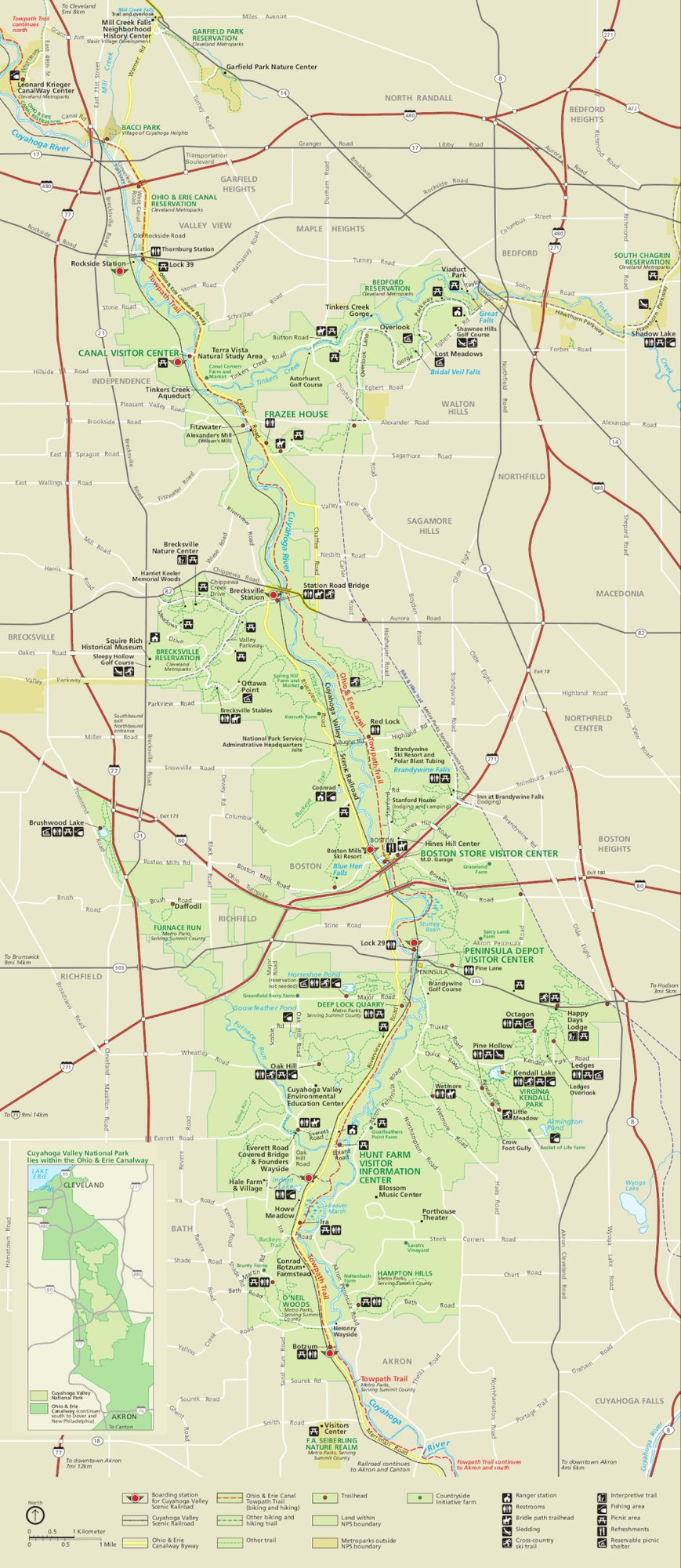
Visitor map
Travel tips
Getting there: the park lies between Cleveland and Akron, about 30 to 40 minutes' drive from Cleveland Hopkins International Airport. A car is the practical choice; there is no public transport covering the whole park.
Scenic railroad: the Cuyahoga Valley Scenic Railroad runs along the river valley; you can ride one way and return by bicycle or on foot.
Towpath: the Towpath Trail follows the old Ohio and Erie Canal, is level, and can be walked or cycled; it is the main route through the park.
Brandywine Falls: about 20 metres high, with a boardwalk and viewing platforms a short walk from the road.
Other sights: The Ledges trail passes rock crevices and small caves; Hale Farm has a reconstructed 19th-century village.
Time: one day covers the falls, one or two trails and a stretch of the towpath.
Season: autumn brings colour and the most visitors; in winter there is snow and some skiing.
Where to stay: the park has two lodgings, Stanford House and the Inn at Brandywine Falls, with limited rooms; most hotels are in Akron, Cleveland and nearby towns.
Caution: the park is made of several separate areas interspersed with towns and roads, so check the map before setting out.
Map
